
Automated Water Gauges: Increasing the responsiveness of the Early Warning System
Published: Sep 15, 2017 Reading time: 5 minutes Share: Share an articleWith the aim of reducing the vulnerability of the Cambodian population to floods, PIN has co-developed and piloted the use of automated water gauges. Automated water gauges have substantially improved the responsiveness of Cambodia’s Early Warning System to floods by continuously recording water levels and transmitting the data for immediate evaluation.
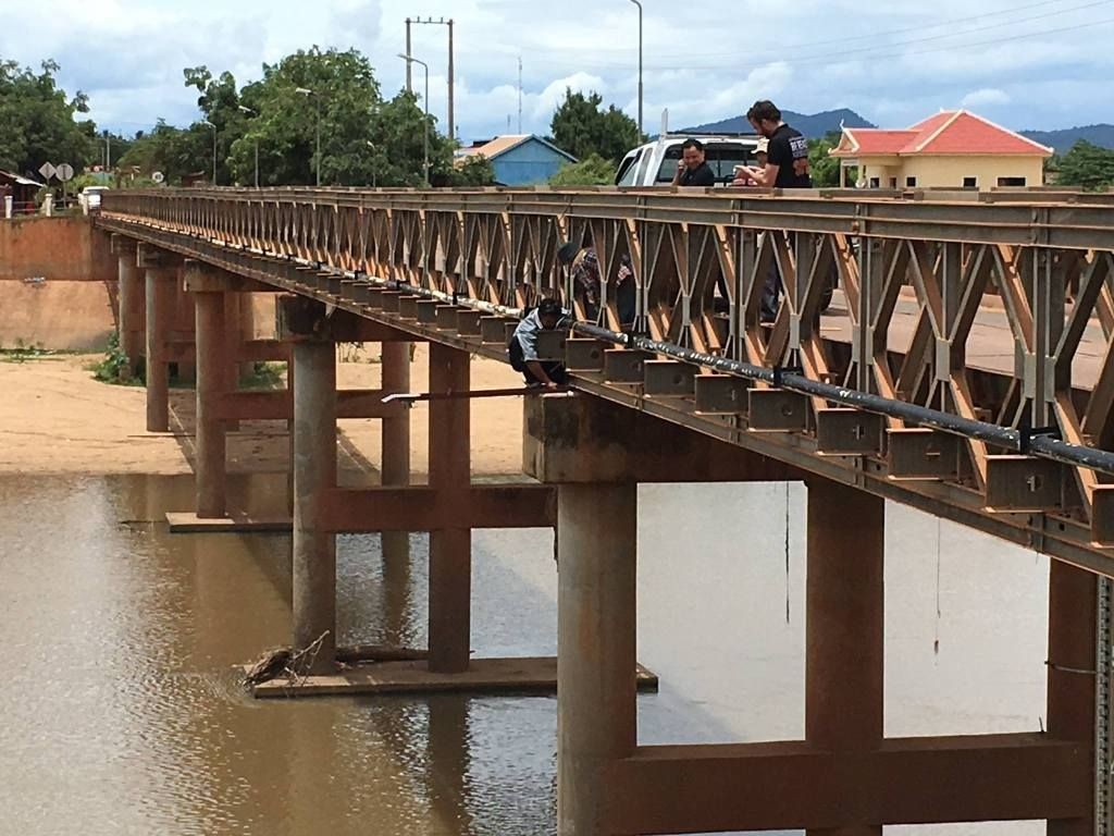
An automated water gauge is a flood detection unit that monitors river water levels. Powered by solar energy, this solar-based device measures precise water levels every 15 minutes and transmits the data across a mobile phone network to a centralised online server where the information is then analysed by PIN. A live stream of water level data can be watched online. If the data collected by the gauges is evaluated and it is deemed that threshold levels have been reached, a pre-recorded audio message is sent to registered users in affected areas using Interactive voice response (IVR) technology. The message, either a warning or an emergency notification, also contains advice on the best course of action appropriate to the location in question. Automated water gauges represent a crucial component of the Early Warning System (EWS) which was introduced to Cambodia by PIN in 2013.
The water gauge device was developed by PIN in partnership with Development Alternatives Incorporated (DAI) from the United States and Development Innovations (DI) from Cambodia, and was introduced as part of PIN DRR programmes in Cambodia in 2016. To the best of our knowledge, PIN-developed flood detectors are the only solar-powered, GSM-enabled and sonar-based water gauges installed in Cambodia or anywhere else.
Context
Cambodia is one of the most hazard-prone countries in South-East Asia as it experiences a large variety of incidents, from floods, drought and fires, lightning and storms, to epidemics and pest outbreaks. As a result of climate change, weather patterns are becoming more severe and erratic. Additionally, the frequency and intensity of natural disasters in Cambodia is on the rise. As the majority of local farmers are primarily dependent on alluvial or rain-fed agriculture, natural disasters have devastating consequences on the livelihoods and food security of vulnerable populations.
However, slow processing of water level data has posed a significant challenge to the effectiveness of EWS since its inception. Detection of dangerous water levels at the site, subsequent approval of procedure at the subnational level, the recording of a warning message and its dissemination by NCDM to the EWS network was a process soon to be found inadequately slow and heavily dependent on uninterrupted availability of all concerned staff. PIN was therefore on the lookout for means of improving the speed of data processing and the overall efficiency of the EWS service. Since commercial grade hydrology stations were found unsuitable for use in Cambodia due to their requirements of high initial investment, extensive technical expertise and parts availability for their maintenance, PIN proceeded to develop its own automated water gauge in partnership with DAI and DI.
IMPLEMENTATION
The idea to develop automated water gauges originally came from director of DAI Maker Lab and was further customised by PIN’s Technology for Development Manager. PIN staff attended a Maker Lab in Phnom Penh in early 2016 to investigate the possibility of using IoT technology within development programmes, and thereafter they became familiar enough with the putative device to attempt to construct it. Following months of consultations and planning, PIN signed an agreement concerning collaboration with DAI and DI which outlined the design of automated water gauges, their installation and the training of office staff in their use and maintenance.
Afterwards, the PIN DRR manager selected two flood prone sites in the provinces of Kampot and Pursat for the installation and the initial testing of the automated water gauges. The existing relationship with provincial governments from PIN’s work on Early Warning System played an important role in the final selection of the piloting sites. PIN sought authorisation from the provincial governments to install the devices and to trial early warning messages on registered people in the affected areas.
Using PIN’s own drone to conduct an aerial elevation assessment and in consultation with international river management specialists, PIN determined ‘warning’ and ‘emergency’ water levels for the selected sites and surrounding areas.
Achievements
In August 2016, a DAI engineer delivered the supplies and the necessary equipment to PIN in Cambodia. The engineer also conducted training sessions on use and device maintenance for local staff. With the assistance of the provincial governments and some local knowledge, the devices were successfully attached to concrete and steel bridges and installed. There has been no hardware related issues due to natural or manmade damage to the devices thus far. However, remote troubleshooting of issues has been difficult to accomplish. Therefore, should you employ similar devices in the future, consider carefully investing into a local code developer.
During the last two years, PIN’s Early Warning System has gathered more than 45,000 registered users and has been used on numerous occasions during severe weather events. Since their installation, flood detection units have been logging important data. Although water levels at selected sites have not yet reach thresholds which would trigger ‘live’ emergencies, conducted simulations have shown all components of EWS (detection, logging and mobile voice messaging) to be working properly. There is therefore no reason to think that the system would not do function in event of a real emergency. The status of automated water gauges has also been monitored by Early Warning System’s dashboard should they fail for any reason.
Next steps
PIN will continue to monitor installed devices during their trial period, refine their source code and examine any of potential software or hardware related issues. If the trial proves successful, PIN plans to increase geographical coverage of automated water gauges in order to reach more populations who live in flood prone areas and to contribute to the country’s overall water level data collection. PIN is currently outlining plans for the installation of a further 25 sensors using funding from the EU and UN ESCAP. In the next rollout, PIN also plans to use a new model of the sensor which can be updated remotely. While hardware limitations and battery life currently allow for device configuration only within close proximity, new sensors should enable PIN to control devices spread around the country from its head office. If you want to learn more about automated water gauges, contact Piotr Sasin at piotr.sasin@peopleinneed.cz.
